Toolbar

Basemaps - Click the button and then choose the background map to display.
Full Extent - Click the button to zoom to the full extent (i.e., countywide boundary) of the map.
Parcel Landuse - Click the button and then click on a point on the map. A pop-up window will be displayed containing the parcel's land use acreage and property information.
Sample of pop-up window:
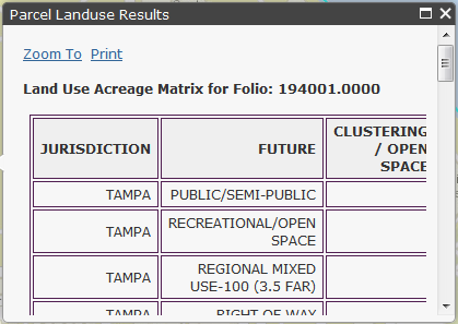
 - Maximize pop-up window for easier viewing.
 - Close pop-up window.
"Zoom to" the feature.
"Print" contents of the pop-up window.
To relocate the pop-up window, move the mouse pointer to the header or footer of the pop-up window. Then click and drag the pop-up window to a new location.
Bird's Eye - Click the button and then click on a point on the map. Bird's Eye imagery will open in another browser window centered at the location where you clicked.
Street View - Click the button and then click on a point on the map (be sure to click on a road or intersection). Google Street View will open in another browser window at the location where you clicked.
Print - Click the button to generate a printable page containing the map and legend. Please be patient while the system creates your print page.
Printing Requirements:
- Your browser must allow pop-up windows from "http://gis.tpcmaps.org".
Printing Instructions:
- Click the "Print" button in the toolbar -- a new browser window will open containing the print output.
- To print the page, use your browser's printing options (e.g., from the browser's menu, choose File | Print).
- In your Printer Properties/Preferences:
- As needed, set the orientation to Portrait or Landscape.
- As needed, set the "scaling" option to fit to paper size.
Printing Tips:
- On the "Print Map" page, right-click on the map to save the map as an image file to your computer.
- Turn off any unneeded map layers. This will reduce processing time, map image file size, and length of the legend.
- Zoom in as close as possible to the area of interest. Less "data" being printed will reduce processing time.
Print Legend - Click the color palette button to print the map legend.